The Koreans know them as Dokdo. The Japanese call them Takeshima. Western countries know them as the Liancourt Rocks, named after a French ship that almost smacked into one of them back in 1849.
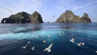 Whatever you call them, however, these volcanic rock islets are home to pretty much no one, but have found themselves home to a long-standing territorial dispute between Japan and South Korea, who both claim ownership. A newly found, 156-year-old map is restarting this dispute.
South Korea has de facto control over the islands right now, and has since the end of World War 2. The territory being ceded by Imperial Japan after the war was complicated though, and there were so many conflicting place names that a lot of the unoccupied islands that changed hands were never specifically named in the peace treaty. Unsurprisingly, the rocks didn’t make the cut either.
The map seems to support the Korean claim to the islands, showing them as part of the 19th century Korean Kingdom. Japan claims the rocks are inherently part of the Japanese archipelago, and that they also claimed them at various points in history.
Either way, the real goal is the same as with a lot of these unoccupied islands: energy resources. Underneath the rocks lies a substantial natural gas reserve, and that’s going to be exploited by whichever country ultimately wins out on this claim. In the meantime, the two nations are just getting angrier and angrier at one another.